Leica Geosystems Introduces New Airborne Bathymetric LiDAR Solution
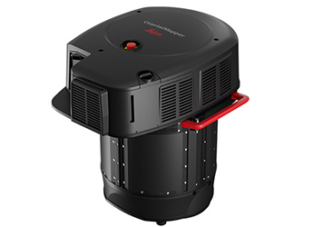
Leica Geosystems, part of Hexagon, has launched the Leica CoastalMapper, an airborne bathymetric LiDAR system designed to improve hydrographic survey efficiency. The system combines a high-performance bathymetric LiDAR module with the Leica TerrainMapper-3 topographic LiDAR and imaging sensor, capturing up to one million bathymetric data points per second and two million topographic points per second. Capable of operating from both fixed-wing aircraft and helicopters, the CoastalMapper is suited for applications ranging from coastal mapping to flood monitoring and environmental studies.
By integrating bathymetric and topographic LiDAR with imaging, the system enables comprehensive data collection in a single flight, reducing survey time, costs, and environmental impact. Leica Geosystems says that its compatibility with existing workflows streamlines operations for users, while cluster processing capabilities allow for efficient analysis of large data sets.
“We aim to empower our community with tools that meet current needs, anticipate future challenges and push the boundaries of bathymetric mapping. We’re beyond pleased to offer our customers this radically enhanced system for more detailed and efficient surveys.” said Anders Ekelund, Vice President of Airborne Bathymetric LiDAR at Leica Geosystems.
For more information
Categories: Geotechnical Services GPS Surveying & Guidance
2025-03-18 | Leica Geosystems AG | Switzerland | Views 201
More from Leica Geosystems AG